|
|
|||||||||||||||||
| Point ID: 6230 | Downloads | Plots | Site Data | Code: 3217 |
|
|
|||||||||||||||||
| Download | |
|---|---|
| Site Descriptor Information | Site Time Series Data |
| Link to all available data | |
| View: | Time Series | All |
| Units: | mm |
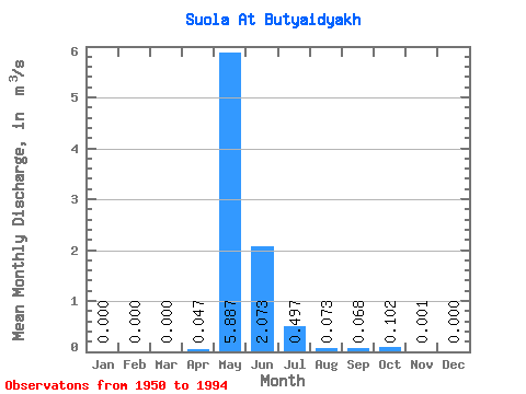
| Statistic | Jan | Feb | Mar | Apr | May | Jun | Jul | Aug | Sep | Oct | Nov | Dec | Annual |
|---|---|---|---|---|---|---|---|---|---|---|---|---|---|
| Mean | 0.00 | 0.00 | 0.00 | 0.05 | 5.89 | 2.07 | 0.50 | 0.07 | 0.07 | 0.10 | 0.00 | 0.00 | 0.74 |
| Standard Deviation | 0.00 | 0.00 | 0.00 | 0.22 | 8.21 | 2.91 | 1.18 | 0.18 | 0.18 | 0.52 | 0.00 | 0.00 | 0.87 |
| Min | 0.00 | 0.00 | 0.00 | 0.00 | 0.04 | 0.00 | 0.00 | 0.00 | 0.00 | 0.00 | 0.00 | 0.00 | 0.02 |
| Max | 0.00 | 0.00 | 0.00 | 1.39 | 33.60 | 13.70 | 6.88 | 1.13 | 1.01 | 3.27 | 0.01 | 0.00 | 3.42 |
| Coefficient of Variation | 4.71 | 1.39 | 1.41 | 2.38 | 2.49 | 2.61 | 5.03 | 4.06 | 1.17 |
 Return to R-Arctic Net Home Page