|
|
|||||||||||||||||
| Point ID: 6218 | Downloads | Plots | Site Data | Code: 3171 |
|
|
|||||||||||||||||
| Download | |
|---|---|
| Site Descriptor Information | Site Time Series Data |
| Link to all available data | |
| View: | Time Series | All |
| Units: | m3/s |
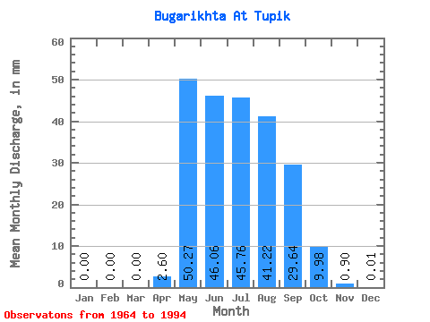
| Statistic | Jan | Feb | Mar | Apr | May | Jun | Jul | Aug | Sep | Oct | Nov | Dec | Annual |
|---|---|---|---|---|---|---|---|---|---|---|---|---|---|
| Mean | 0.00 | 0.00 | 0.00 | 2.60 | 50.26 | 46.06 | 45.76 | 41.21 | 29.64 | 9.98 | 0.90 | 0.01 | 223.65 |
| Standard Deviation | 0.00 | 0.00 | 0.00 | 3.98 | 28.66 | 38.21 | 35.00 | 30.53 | 16.05 | 5.28 | 0.74 | 0.04 | 96.01 |
| Min | 0.00 | 0.00 | 0.00 | 0.00 | 13.53 | 3.60 | 2.54 | 5.71 | 4.56 | 2.49 | 0.03 | 0.00 | 77.77 |
| Max | 0.00 | 0.00 | 0.00 | 15.67 | 102.38 | 129.83 | 154.52 | 97.17 | 65.83 | 21.73 | 3.44 | 0.17 | 478.85 |
| Coefficient of Variation | 1.53 | 0.57 | 0.83 | 0.77 | 0.74 | 0.54 | 0.53 | 0.82 | 2.65 | 0.43 |
 Return to R-Arctic Net Home Page