|
|
|||||||||||||||||
| Point ID: 6218 | Downloads | Plots | Site Data | Code: 3171 |
|
|
|||||||||||||||||
| Download | |
|---|---|
| Site Descriptor Information | Site Time Series Data |
| Link to all available data | |
| View: | Time Series | All |
| Units: | mm |
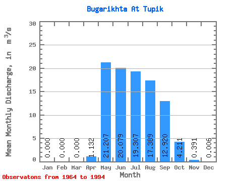
| Statistic | Jan | Feb | Mar | Apr | May | Jun | Jul | Aug | Sep | Oct | Nov | Dec | Annual |
|---|---|---|---|---|---|---|---|---|---|---|---|---|---|
| Mean | 0.00 | 0.00 | 0.00 | 1.13 | 21.21 | 20.08 | 19.31 | 17.39 | 12.92 | 4.21 | 0.39 | 0.01 | 8.01 |
| Standard Deviation | 0.00 | 0.00 | 0.00 | 1.74 | 12.09 | 16.66 | 14.77 | 12.88 | 7.00 | 2.23 | 0.32 | 0.01 | 3.44 |
| Min | 0.00 | 0.00 | 0.00 | 0.00 | 5.71 | 1.57 | 1.07 | 2.41 | 1.99 | 1.05 | 0.01 | 0.00 | 2.79 |
| Max | 0.00 | 0.00 | 0.00 | 6.83 | 43.20 | 56.60 | 65.20 | 41.00 | 28.70 | 9.17 | 1.50 | 0.07 | 17.14 |
| Coefficient of Variation | 1.53 | 0.57 | 0.83 | 0.77 | 0.74 | 0.54 | 0.53 | 0.82 | 2.65 | 0.43 |
 Return to R-Arctic Net Home Page