|
|
|||||||||||||||||
| Point ID: 6217 | Downloads | Plots | Site Data | Code: 3170 |
|
|
|||||||||||||||||
| Download | |
|---|---|
| Site Descriptor Information | Site Time Series Data |
| Link to all available data | |
| View: | Time Series | All |
| Units: | m3/s |
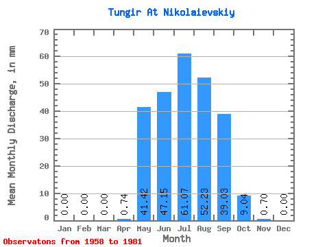
| Statistic | Jan | Feb | Mar | Apr | May | Jun | Jul | Aug | Sep | Oct | Nov | Dec | Annual |
|---|---|---|---|---|---|---|---|---|---|---|---|---|---|
| Mean | 0.00 | 0.00 | 0.00 | 0.74 | 41.42 | 47.15 | 61.06 | 52.23 | 39.02 | 9.04 | 0.70 | 0.00 | 249.70 |
| Standard Deviation | 0.00 | 0.00 | 0.00 | 1.71 | 28.51 | 42.95 | 41.54 | 35.39 | 27.60 | 5.76 | 0.84 | 0.01 | 94.52 |
| Min | 0.00 | 0.00 | 0.00 | 0.00 | 4.50 | 2.20 | 11.18 | 7.93 | 8.85 | 3.36 | 0.04 | 0.00 | 104.55 |
| Max | 0.00 | 0.00 | 0.00 | 6.86 | 125.55 | 190.15 | 183.39 | 151.25 | 127.73 | 27.64 | 3.46 | 0.06 | 448.19 |
| Coefficient of Variation | 2.32 | 0.69 | 0.91 | 0.68 | 0.68 | 0.71 | 0.64 | 1.20 | 3.17 | 0.38 |
 Return to R-Arctic Net Home Page