|
|
|||||||||||||||||
| Point ID: 6217 | Downloads | Plots | Site Data | Code: 3170 |
|
|
|||||||||||||||||
| Download | |
|---|---|
| Site Descriptor Information | Site Time Series Data |
| Link to all available data | |
| View: | Time Series | All |
| Units: | mm |
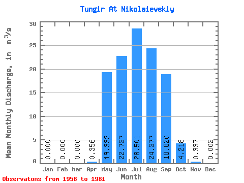
| Statistic | Jan | Feb | Mar | Apr | May | Jun | Jul | Aug | Sep | Oct | Nov | Dec | Annual |
|---|---|---|---|---|---|---|---|---|---|---|---|---|---|
| Mean | 0.00 | 0.00 | 0.00 | 0.36 | 19.33 | 22.74 | 28.50 | 24.38 | 18.82 | 4.22 | 0.34 | 0.00 | 9.89 |
| Standard Deviation | 0.00 | 0.00 | 0.00 | 0.82 | 13.31 | 20.71 | 19.39 | 16.52 | 13.31 | 2.69 | 0.41 | 0.01 | 3.74 |
| Min | 0.00 | 0.00 | 0.00 | 0.00 | 2.10 | 1.06 | 5.22 | 3.70 | 4.27 | 1.57 | 0.02 | 0.00 | 4.14 |
| Max | 0.00 | 0.00 | 0.00 | 3.31 | 58.60 | 91.70 | 85.60 | 70.60 | 61.60 | 12.90 | 1.67 | 0.03 | 17.75 |
| Coefficient of Variation | 2.32 | 0.69 | 0.91 | 0.68 | 0.68 | 0.71 | 0.64 | 1.20 | 3.17 | 0.38 |
 Return to R-Arctic Net Home Page