|
|
|||||||||||||||||
| Point ID: 6216 | Downloads | Plots | Site Data | Code: 3169 |
|
|
|||||||||||||||||
| Download | |
|---|---|
| Site Descriptor Information | Site Time Series Data |
| Link to all available data | |
| View: | Time Series | All |
| Units: | m3/s |
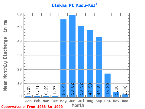
| Statistic | Jan | Feb | Mar | Apr | May | Jun | Jul | Aug | Sep | Oct | Nov | Dec | Annual |
|---|---|---|---|---|---|---|---|---|---|---|---|---|---|
| Mean | 1.09 | 0.71 | 0.69 | 1.29 | 55.44 | 58.62 | 50.92 | 47.52 | 42.81 | 16.80 | 3.90 | 2.00 | 280.29 |
| Standard Deviation | 0.45 | 0.29 | 0.29 | 1.64 | 21.60 | 27.32 | 25.55 | 23.56 | 19.07 | 6.58 | 1.45 | 0.71 | 71.64 |
| Min | 0.40 | 0.21 | 0.20 | 0.15 | 20.00 | 21.37 | 15.23 | 12.06 | 11.90 | 5.45 | 1.23 | 0.71 | 134.57 |
| Max | 2.42 | 1.43 | 1.46 | 9.94 | 136.23 | 156.20 | 160.21 | 132.27 | 98.72 | 34.93 | 9.67 | 3.61 | 429.75 |
| Coefficient of Variation | 0.41 | 0.41 | 0.41 | 1.27 | 0.39 | 0.47 | 0.50 | 0.50 | 0.45 | 0.39 | 0.37 | 0.36 | 0.26 |
 Return to R-Arctic Net Home Page