|
|
|||||||||||||||||
| Point ID: 6216 | Downloads | Plots | Site Data | Code: 3169 |
|
|
|||||||||||||||||
| Download | |
|---|---|
| Site Descriptor Information | Site Time Series Data |
| Link to all available data | |
| View: | Time Series | All |
| Units: | mm |
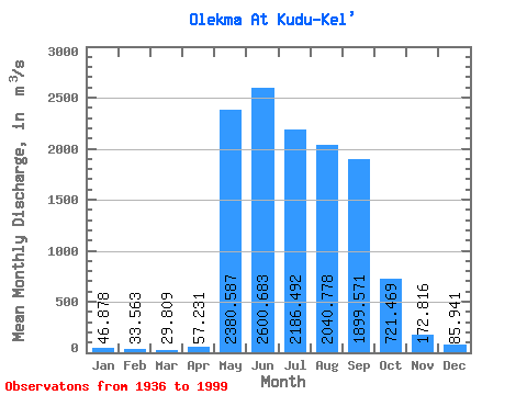
| Statistic | Jan | Feb | Mar | Apr | May | Jun | Jul | Aug | Sep | Oct | Nov | Dec | Annual |
|---|---|---|---|---|---|---|---|---|---|---|---|---|---|
| Mean | 46.88 | 33.56 | 29.81 | 57.23 | 2380.59 | 2600.68 | 2186.49 | 2040.78 | 1899.57 | 721.47 | 172.82 | 85.94 | 1021.34 |
| Standard Deviation | 19.09 | 13.81 | 12.31 | 72.55 | 927.43 | 1212.19 | 1096.97 | 1011.86 | 846.19 | 282.72 | 64.50 | 30.67 | 261.03 |
| Min | 17.30 | 10.10 | 8.40 | 6.65 | 859.00 | 948.00 | 654.00 | 518.00 | 528.00 | 234.00 | 54.70 | 30.40 | 490.37 |
| Max | 104.00 | 67.40 | 62.80 | 441.00 | 5850.00 | 6930.00 | 6880.00 | 5680.00 | 4380.00 | 1500.00 | 429.00 | 155.00 | 1565.93 |
| Coefficient of Variation | 0.41 | 0.41 | 0.41 | 1.27 | 0.39 | 0.47 | 0.50 | 0.50 | 0.45 | 0.39 | 0.37 | 0.36 | 0.26 |
 Return to R-Arctic Net Home Page