|
|
|||||||||||||||||
| Point ID: 6215 | Downloads | Plots | Site Data | Code: 3167 |
|
|
|||||||||||||||||
| Download | |
|---|---|
| Site Descriptor Information | Site Time Series Data |
| Link to all available data | |
| View: | Time Series | All |
| Units: | m3/s |
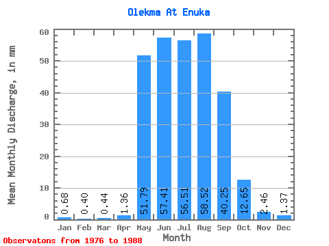
| Statistic | Jan | Feb | Mar | Apr | May | Jun | Jul | Aug | Sep | Oct | Nov | Dec | Annual |
|---|---|---|---|---|---|---|---|---|---|---|---|---|---|
| Mean | 0.68 | 0.41 | 0.44 | 1.36 | 51.78 | 57.41 | 56.50 | 58.51 | 40.25 | 12.65 | 2.46 | 1.37 | 288.89 |
| Standard Deviation | 0.29 | 0.18 | 0.23 | 1.53 | 26.40 | 27.70 | 28.47 | 31.53 | 17.33 | 5.17 | 0.64 | 0.39 | 89.16 |
| Min | 0.34 | 0.18 | 0.13 | 0.28 | 13.20 | 18.88 | 14.65 | 14.10 | 12.93 | 6.89 | 1.39 | 0.82 | 119.94 |
| Max | 1.32 | 0.92 | 1.08 | 5.58 | 92.47 | 124.29 | 100.97 | 105.91 | 69.58 | 22.97 | 3.75 | 2.11 | 390.97 |
| Coefficient of Variation | 0.43 | 0.45 | 0.51 | 1.12 | 0.51 | 0.48 | 0.50 | 0.54 | 0.43 | 0.41 | 0.26 | 0.28 | 0.31 |
 Return to R-Arctic Net Home Page