|
|
|||||||||||||||||
| Point ID: 6215 | Downloads | Plots | Site Data | Code: 3167 |
|
|
|||||||||||||||||
| Download | |
|---|---|
| Site Descriptor Information | Site Time Series Data |
| Link to all available data | |
| View: | Time Series | All |
| Units: | mm |
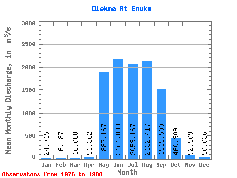
| Statistic | Jan | Feb | Mar | Apr | May | Jun | Jul | Aug | Sep | Oct | Nov | Dec | Annual |
|---|---|---|---|---|---|---|---|---|---|---|---|---|---|
| Mean | 24.71 | 16.19 | 16.09 | 51.36 | 1887.17 | 2161.83 | 2059.17 | 2132.42 | 1515.50 | 460.91 | 92.51 | 50.04 | 893.39 |
| Standard Deviation | 10.53 | 7.26 | 8.22 | 57.66 | 962.20 | 1043.16 | 1037.63 | 1149.17 | 652.48 | 188.41 | 24.11 | 14.06 | 275.74 |
| Min | 12.20 | 7.14 | 4.66 | 10.70 | 481.00 | 711.00 | 534.00 | 514.00 | 487.00 | 251.00 | 52.50 | 29.90 | 370.93 |
| Max | 48.30 | 36.60 | 39.30 | 210.00 | 3370.00 | 4680.00 | 3680.00 | 3860.00 | 2620.00 | 837.00 | 141.00 | 77.00 | 1209.08 |
| Coefficient of Variation | 0.43 | 0.45 | 0.51 | 1.12 | 0.51 | 0.48 | 0.50 | 0.54 | 0.43 | 0.41 | 0.26 | 0.28 | 0.31 |
 Return to R-Arctic Net Home Page