|
|
|||||||||||||||||
| Point ID: 6205 | Downloads | Plots | Site Data | Code: 3152 |
|
|
|||||||||||||||||
| Download | |
|---|---|
| Site Descriptor Information | Site Time Series Data |
| Link to all available data | |
| View: | Time Series | All |
| Units: | m3/s |
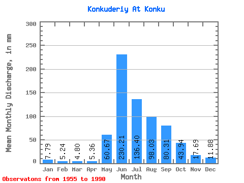
| Statistic | Jan | Feb | Mar | Apr | May | Jun | Jul | Aug | Sep | Oct | Nov | Dec | Annual |
|---|---|---|---|---|---|---|---|---|---|---|---|---|---|
| Mean | 7.79 | 5.29 | 4.79 | 5.36 | 60.66 | 230.21 | 136.38 | 98.02 | 80.31 | 43.94 | 17.69 | 11.87 | 703.00 |
| Standard Deviation | 2.21 | 1.66 | 1.50 | 1.65 | 24.45 | 46.72 | 49.25 | 34.19 | 26.61 | 9.84 | 5.72 | 3.61 | 111.56 |
| Min | 4.83 | 1.91 | 2.11 | 2.59 | 12.96 | 165.42 | 62.60 | 49.59 | 41.83 | 26.40 | 8.22 | 4.51 | 487.63 |
| Max | 13.66 | 9.32 | 8.71 | 9.96 | 117.03 | 351.39 | 223.17 | 198.67 | 159.63 | 62.05 | 33.56 | 20.68 | 909.94 |
| Coefficient of Variation | 0.28 | 0.31 | 0.31 | 0.31 | 0.40 | 0.20 | 0.36 | 0.35 | 0.33 | 0.22 | 0.32 | 0.30 | 0.16 |
 Return to R-Arctic Net Home Page