|
|
|||||||||||||||||
| Point ID: 6205 | Downloads | Plots | Site Data | Code: 3152 |
|
|
|||||||||||||||||
| Download | |
|---|---|
| Site Descriptor Information | Site Time Series Data |
| Link to all available data | |
|
|
| View: | Statistics | Time Series |
| Units: | m3/s |
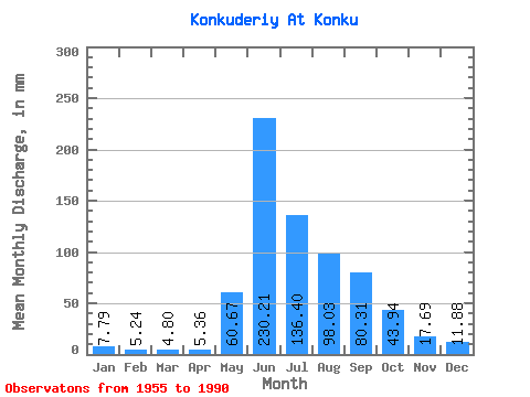
| Statistic | Jan | Feb | Mar | Apr | May | Jun | Jul | Aug | Sep | Oct | Nov | Dec | Annual |
|---|---|---|---|---|---|---|---|---|---|---|---|---|---|
| Mean | 7.79 | 5.29 | 4.79 | 5.36 | 60.66 | 230.21 | 136.38 | 98.02 | 80.31 | 43.94 | 17.69 | 11.87 | 703.00 |
| Standard Deviation | 2.21 | 1.66 | 1.50 | 1.65 | 24.45 | 46.72 | 49.25 | 34.19 | 26.61 | 9.84 | 5.72 | 3.61 | 111.56 |
| Min | 4.83 | 1.91 | 2.11 | 2.59 | 12.96 | 165.42 | 62.60 | 49.59 | 41.83 | 26.40 | 8.22 | 4.51 | 487.63 |
| Max | 13.66 | 9.32 | 8.71 | 9.96 | 117.03 | 351.39 | 223.17 | 198.67 | 159.63 | 62.05 | 33.56 | 20.68 | 909.94 |
| Coefficient of Variation | 0.28 | 0.31 | 0.31 | 0.31 | 0.40 | 0.20 | 0.36 | 0.35 | 0.33 | 0.22 | 0.32 | 0.30 | 0.16 |
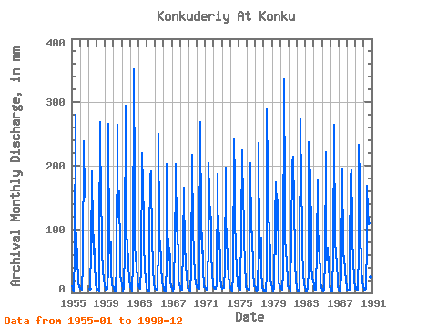
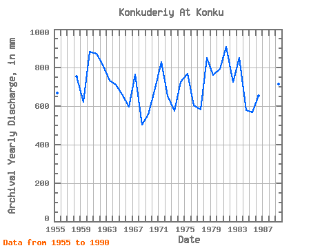
| Year | Jan | Feb | Mar | Apr | May | Jun | Jul | Aug | Sep | Oct | Nov | Dec | Annual | 1955 | 11.27 | 9.32 | 4.83 | 4.22 | 63.14 | 280.27 | 101.24 | 92.53 | 49.94 | 26.40 | 15.17 | 9.53 | 668.18 | 1956 | 6.86 | 7.34 | 7.35 | 5.53 | 47.52 | 239.18 | 157.85 | 1957 | 6.90 | 71.85 | 191.24 | 100.70 | 62.60 | 91.67 | 50.40 | 13.22 | 9.47 | 1958 | 5.11 | 6.05 | 5.16 | 2.89 | 80.56 | 269.21 | 132.27 | 115.39 | 65.85 | 39.84 | 19.91 | 13.55 | 754.49 | 1959 | 5.88 | 6.35 | 6.64 | 6.48 | 43.49 | 266.05 | 64.77 | 81.10 | 80.08 | 36.41 | 12.06 | 10.94 | 621.63 | 1960 | 8.76 | 5.85 | 4.43 | 4.26 | 45.01 | 263.94 | 123.01 | 162.20 | 159.63 | 59.87 | 27.29 | 20.68 | 884.48 | 1961 | 13.66 | 4.60 | 4.13 | 6.69 | 71.85 | 293.97 | 223.17 | 91.44 | 80.61 | 43.38 | 22.55 | 19.32 | 873.28 | 1962 | 11.65 | 5.85 | 4.50 | 3.62 | 47.90 | 351.39 | 174.72 | 73.48 | 60.59 | 37.94 | 25.23 | 17.09 | 814.30 | 1963 | 11.05 | 7.59 | 6.75 | 6.43 | 41.75 | 220.74 | 174.18 | 120.29 | 74.81 | 42.56 | 18.23 | 12.08 | 734.42 | 1964 | 6.53 | 3.89 | 3.25 | 3.90 | 87.63 | 183.86 | 198.13 | 75.66 | 87.98 | 41.37 | 15.70 | 7.13 | 712.09 | 1965 | 6.59 | 5.55 | 5.25 | 4.92 | 81.65 | 249.72 | 102.87 | 69.13 | 62.17 | 44.14 | 16.65 | 12.90 | 661.07 | 1966 | 7.08 | 4.38 | 2.77 | 3.28 | 49.15 | 203.36 | 124.10 | 52.96 | 71.12 | 52.36 | 17.91 | 9.74 | 597.55 | 1967 | 7.08 | 3.20 | 2.18 | 9.96 | 87.63 | 167.53 | 210.10 | 100.70 | 95.88 | 56.61 | 16.38 | 13.44 | 766.63 | 1968 | 8.71 | 4.81 | 4.70 | 5.13 | 78.92 | 165.42 | 62.60 | 82.73 | 41.83 | 30.97 | 10.80 | 8.55 | 503.85 | 1969 | 7.08 | 5.11 | 4.22 | 3.68 | 36.20 | 216.53 | 98.52 | 69.67 | 59.53 | 29.83 | 13.86 | 12.30 | 556.60 | 1970 | 10.34 | 7.74 | 6.64 | 6.01 | 67.49 | 268.68 | 108.32 | 64.77 | 94.30 | 40.77 | 9.06 | 8.93 | 693.69 | 1971 | 7.89 | 6.65 | 5.77 | 7.06 | 94.17 | 204.41 | 160.57 | 118.66 | 119.06 | 62.05 | 33.56 | 11.48 | 828.93 | 1972 | 8.93 | 7.14 | 7.08 | 5.85 | 12.96 | 187.55 | 148.60 | 103.42 | 87.98 | 50.19 | 25.23 | 11.16 | 654.99 | 1973 | 6.80 | 6.94 | 8.71 | 8.32 | 40.17 | 197.56 | 111.04 | 99.06 | 45.78 | 28.85 | 12.91 | 11.81 | 576.89 | 1974 | 7.67 | 4.31 | 3.93 | 4.06 | 29.61 | 242.87 | 180.17 | 121.92 | 67.96 | 38.48 | 14.86 | 12.25 | 726.20 | 1975 | 8.55 | 5.11 | 4.74 | 8.17 | 106.14 | 224.43 | 140.98 | 127.37 | 80.61 | 51.00 | 9.59 | 6.31 | 770.13 | 1976 | 6.70 | 5.60 | 5.71 | 4.84 | 30.92 | 204.94 | 98.52 | 96.89 | 95.36 | 34.24 | 11.33 | 10.67 | 605.70 | 1977 | 8.44 | 4.74 | 2.85 | 5.43 | 68.04 | 235.49 | 63.68 | 57.15 | 87.45 | 37.45 | 8.22 | 4.51 | 584.42 | 1978 | 5.19 | 4.01 | 3.47 | 3.17 | 32.55 | 290.28 | 193.77 | 132.27 | 91.14 | 60.96 | 22.29 | 15.08 | 852.51 | 1979 | 7.84 | 3.93 | 4.75 | 6.11 | 117.03 | 174.38 | 63.68 | 160.03 | 138.03 | 57.70 | 15.75 | 13.82 | 760.64 | 1980 | 8.82 | 6.00 | 5.36 | 5.58 | 35.92 | 336.12 | 160.03 | 88.18 | 66.91 | 48.93 | 20.12 | 11.81 | 794.10 | 1981 | 7.62 | 5.75 | 3.78 | 6.48 | 90.90 | 204.41 | 220.99 | 142.06 | 146.46 | 55.52 | 15.07 | 14.59 | 909.94 | 1982 | 6.97 | 3.38 | 3.05 | 3.29 | 31.03 | 275.00 | 166.56 | 112.67 | 67.96 | 33.97 | 13.01 | 10.02 | 725.91 | 1983 | 5.55 | 3.53 | 3.94 | 6.38 | 39.14 | 237.60 | 193.77 | 198.67 | 77.97 | 44.74 | 23.55 | 20.41 | 851.52 | 1984 | 11.70 | 5.95 | 5.55 | 4.77 | 72.94 | 178.07 | 112.67 | 71.85 | 57.42 | 33.31 | 15.86 | 10.23 | 578.84 | 1985 | 4.83 | 1.91 | 3.99 | 4.78 | 54.98 | 221.27 | 76.75 | 52.47 | 71.65 | 43.22 | 19.18 | 12.41 | 567.77 | 1986 | 5.50 | 2.87 | 3.61 | 4.97 | 65.32 | 264.47 | 82.19 | 80.01 | 63.75 | 45.34 | 22.55 | 12.74 | 653.48 | 1987 | 4.90 | 2.69 | 2.11 | 2.59 | 39.30 | 195.98 | 68.58 | 49.59 | 58.48 | 34.24 | 19.18 | 9.47 | 487.63 | 1988 | 5.29 | 5.16 | 5.61 | 4.48 | 63.68 | 180.70 | 199.22 | 110.50 | 83.77 | 54.16 | 21.39 | 7.29 | 737.91 | 1989 | 9.80 | 7.54 | 5.34 | 5.64 | 71.85 | 232.33 | 179.08 | 80.01 | 61.64 | 38.32 | 16.44 | 10.99 | 717.11 | 1990 | 6.15 | 4.14 | 5.66 | 7.06 | 85.46 | 168.59 | 132.27 | 113.22 | 65.33 | 52.31 | 25.18 | 12.85 | 675.11 |
|---|
 Return to R-Arctic Net Home Page