|
|
|||||||||||||||||
| Point ID: 6201 | Downloads | Plots | Site Data | Code: 3147 |
|
|
|||||||||||||||||
| Download | |
|---|---|
| Site Descriptor Information | Site Time Series Data |
| Link to all available data | |
| View: | Time Series | All |
| Units: | m3/s |
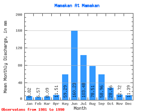
| Statistic | Jan | Feb | Mar | Apr | May | Jun | Jul | Aug | Sep | Oct | Nov | Dec | Annual |
|---|---|---|---|---|---|---|---|---|---|---|---|---|---|
| Mean | 8.82 | 6.63 | 8.09 | 11.51 | 59.28 | 160.23 | 103.47 | 78.50 | 58.96 | 28.66 | 12.72 | 11.39 | 547.00 |
| Standard Deviation | 1.14 | 0.99 | 1.10 | 2.23 | 18.26 | 28.30 | 47.44 | 37.01 | 24.26 | 6.11 | 2.68 | 1.99 | 120.26 |
| Min | 6.91 | 4.49 | 6.20 | 7.67 | 34.25 | 113.98 | 49.54 | 31.14 | 41.37 | 23.21 | 8.22 | 7.90 | 403.06 |
| Max | 10.96 | 7.81 | 9.48 | 15.15 | 87.19 | 211.25 | 190.80 | 143.53 | 122.20 | 41.61 | 17.15 | 14.32 | 800.40 |
| Coefficient of Variation | 0.13 | 0.15 | 0.14 | 0.19 | 0.31 | 0.18 | 0.46 | 0.47 | 0.41 | 0.21 | 0.21 | 0.17 | 0.22 |
 Return to R-Arctic Net Home Page