|
|
|||||||||||||||||
| Point ID: 6201 | Downloads | Plots | Site Data | Code: 3147 |
|
|
|||||||||||||||||
| Download | |
|---|---|
| Site Descriptor Information | Site Time Series Data |
| Link to all available data | |
| View: | Time Series | All |
| Units: | mm |
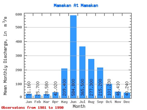
| Statistic | Jan | Feb | Mar | Apr | May | Jun | Jul | Aug | Sep | Oct | Nov | Dec | Annual |
|---|---|---|---|---|---|---|---|---|---|---|---|---|---|
| Mean | 31.16 | 25.70 | 28.58 | 42.02 | 209.40 | 584.80 | 365.50 | 277.30 | 215.20 | 101.23 | 46.41 | 40.24 | 163.96 |
| Standard Deviation | 4.01 | 3.83 | 3.88 | 8.13 | 64.52 | 103.28 | 167.59 | 130.73 | 88.55 | 21.58 | 9.77 | 7.04 | 36.05 |
| Min | 24.40 | 17.40 | 21.90 | 28.00 | 121.00 | 416.00 | 175.00 | 110.00 | 151.00 | 82.00 | 30.00 | 27.90 | 120.82 |
| Max | 38.70 | 30.30 | 33.50 | 55.30 | 308.00 | 771.00 | 674.00 | 507.00 | 446.00 | 147.00 | 62.60 | 50.60 | 239.92 |
| Coefficient of Variation | 0.13 | 0.15 | 0.14 | 0.19 | 0.31 | 0.18 | 0.46 | 0.47 | 0.41 | 0.21 | 0.21 | 0.17 | 0.22 |
 Return to R-Arctic Net Home Page