|
|
|||||||||||||||||
| Point ID: 6200 | Downloads | Plots | Site Data | Code: 3145 |
|
|
|||||||||||||||||
| Download | |
|---|---|
| Site Descriptor Information | Site Time Series Data |
| Link to all available data | |
| View: | Time Series | All |
| Units: | m3/s |
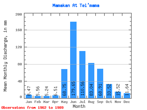
| Statistic | Jan | Feb | Mar | Apr | May | Jun | Jul | Aug | Sep | Oct | Nov | Dec | Annual |
|---|---|---|---|---|---|---|---|---|---|---|---|---|---|
| Mean | 8.47 | 5.61 | 5.24 | 6.50 | 68.74 | 179.65 | 110.55 | 83.03 | 68.91 | 33.52 | 15.52 | 11.64 | 596.01 |
| Standard Deviation | 1.58 | 1.28 | 1.08 | 2.11 | 24.97 | 37.74 | 37.37 | 29.08 | 22.24 | 7.46 | 2.88 | 2.66 | 94.74 |
| Min | 5.17 | 3.26 | 2.83 | 2.60 | 27.10 | 109.99 | 53.15 | 37.59 | 37.23 | 20.35 | 10.15 | 4.99 | 434.15 |
| Max | 11.25 | 8.59 | 7.61 | 13.16 | 115.40 | 263.75 | 181.18 | 150.64 | 131.31 | 53.44 | 20.95 | 15.91 | 813.60 |
| Coefficient of Variation | 0.19 | 0.23 | 0.21 | 0.33 | 0.36 | 0.21 | 0.34 | 0.35 | 0.32 | 0.22 | 0.18 | 0.23 | 0.16 |
 Return to R-Arctic Net Home Page