|
|
|||||||||||||||||
| Point ID: 6200 | Downloads | Plots | Site Data | Code: 3145 |
|
|
|||||||||||||||||
| Download | |
|---|---|
| Site Descriptor Information | Site Time Series Data |
| Link to all available data | |
| View: | Time Series | All |
| Units: | mm |
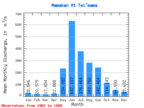
| Statistic | Jan | Feb | Mar | Apr | May | Jun | Jul | Aug | Sep | Oct | Nov | Dec | Annual |
|---|---|---|---|---|---|---|---|---|---|---|---|---|---|
| Mean | 28.85 | 20.98 | 17.83 | 22.89 | 234.08 | 632.11 | 376.46 | 282.75 | 242.46 | 114.14 | 54.59 | 39.63 | 172.23 |
| Standard Deviation | 5.37 | 4.80 | 3.67 | 7.43 | 85.03 | 132.80 | 127.26 | 99.04 | 78.27 | 25.42 | 10.12 | 9.04 | 27.38 |
| Min | 17.60 | 12.20 | 9.65 | 9.16 | 92.30 | 387.00 | 181.00 | 128.00 | 131.00 | 69.30 | 35.70 | 17.00 | 125.46 |
| Max | 38.30 | 32.10 | 25.90 | 46.30 | 393.00 | 928.00 | 617.00 | 513.00 | 462.00 | 182.00 | 73.70 | 54.20 | 235.11 |
| Coefficient of Variation | 0.19 | 0.23 | 0.21 | 0.33 | 0.36 | 0.21 | 0.34 | 0.35 | 0.32 | 0.22 | 0.18 | 0.23 | 0.16 |
 Return to R-Arctic Net Home Page