|
|
|||||||||||||||||
| Point ID: 6190 | Downloads | Plots | Site Data | Code: 3128 |
|
|
|||||||||||||||||
| Download | |
|---|---|
| Site Descriptor Information | Site Time Series Data |
| Link to all available data | |
| View: | Time Series | All |
| Units: | m3/s |
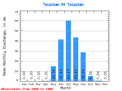
| Statistic | Jan | Feb | Mar | Apr | May | Jun | Jul | Aug | Sep | Oct | Nov | Dec | Annual |
|---|---|---|---|---|---|---|---|---|---|---|---|---|---|
| Mean | 0.00 | 0.00 | 0.00 | 0.30 | 14.94 | 41.61 | 60.26 | 43.62 | 28.84 | 5.25 | 0.64 | 0.06 | 194.34 |
| Standard Deviation | 0.01 | 0.00 | 0.00 | 0.54 | 10.96 | 29.34 | 50.62 | 33.89 | 23.64 | 3.04 | 0.59 | 0.11 | 93.57 |
| Min | 0.00 | 0.00 | 0.00 | 0.00 | 3.77 | 6.97 | 4.24 | 7.60 | 2.83 | 0.89 | 0.02 | 0.00 | 46.92 |
| Max | 0.07 | 0.00 | 0.00 | 2.21 | 46.94 | 122.89 | 202.53 | 118.03 | 117.70 | 11.18 | 2.47 | 0.47 | 406.98 |
| Coefficient of Variation | 5.46 | 1.77 | 0.73 | 0.70 | 0.84 | 0.78 | 0.82 | 0.58 | 0.92 | 2.01 | 0.48 |
 Return to R-Arctic Net Home Page