|
|
|||||||||||||||||
| Point ID: 6190 | Downloads | Plots | Site Data | Code: 3128 |
|
|
|||||||||||||||||
| Download | |
|---|---|
| Site Descriptor Information | Site Time Series Data |
| Link to all available data | |
| View: | Time Series | All |
| Units: | mm |
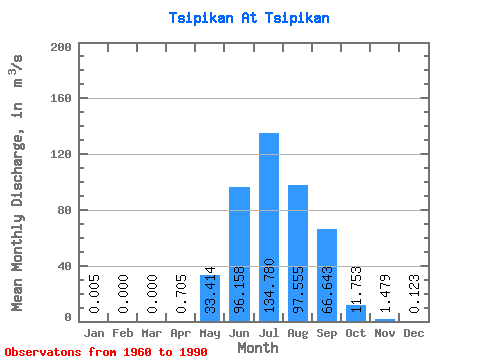
| Statistic | Jan | Feb | Mar | Apr | May | Jun | Jul | Aug | Sep | Oct | Nov | Dec | Annual |
|---|---|---|---|---|---|---|---|---|---|---|---|---|---|
| Mean | 0.01 | 0.00 | 0.00 | 0.70 | 33.41 | 96.16 | 134.78 | 97.56 | 66.64 | 11.75 | 1.48 | 0.12 | 36.88 |
| Standard Deviation | 0.03 | 0.00 | 0.00 | 1.25 | 24.52 | 67.81 | 113.23 | 75.80 | 54.64 | 6.81 | 1.36 | 0.25 | 17.76 |
| Min | 0.00 | 0.00 | 0.00 | 0.00 | 8.44 | 16.10 | 9.49 | 17.00 | 6.54 | 2.00 | 0.05 | 0.00 | 8.91 |
| Max | 0.16 | 0.00 | 0.00 | 5.11 | 105.00 | 284.00 | 453.00 | 264.00 | 272.00 | 25.00 | 5.71 | 1.05 | 77.24 |
| Coefficient of Variation | 5.46 | 1.77 | 0.73 | 0.70 | 0.84 | 0.78 | 0.82 | 0.58 | 0.92 | 2.01 | 0.48 |
 Return to R-Arctic Net Home Page