|
|
|||||||||||||||||
| Point ID: 6186 | Downloads | Plots | Site Data | Code: 3123 |
|
|
|||||||||||||||||
| Download | |
|---|---|
| Site Descriptor Information | Site Time Series Data |
| Link to all available data | |
| View: | Time Series | All |
| Units: | m3/s |
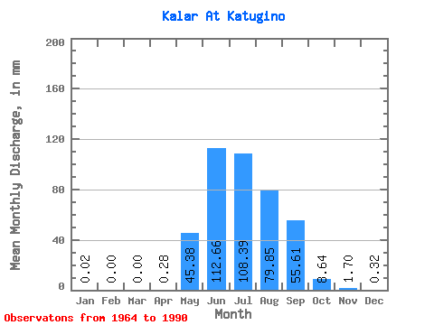
| Statistic | Jan | Feb | Mar | Apr | May | Jun | Jul | Aug | Sep | Oct | Nov | Dec | Annual |
|---|---|---|---|---|---|---|---|---|---|---|---|---|---|
| Mean | 0.02 | 0.00 | 0.00 | 0.28 | 45.37 | 112.66 | 108.37 | 79.84 | 55.60 | 8.64 | 1.70 | 0.32 | 413.57 |
| Standard Deviation | 0.06 | 0.00 | 0.00 | 0.42 | 31.60 | 47.11 | 49.72 | 43.20 | 55.83 | 2.53 | 0.56 | 0.31 | 125.67 |
| Min | 0.00 | 0.00 | 0.00 | 0.00 | 3.69 | 30.05 | 38.93 | 17.89 | 22.77 | 3.23 | 0.40 | 0.00 | 185.03 |
| Max | 0.26 | 0.00 | 0.00 | 1.86 | 151.69 | 199.11 | 239.95 | 177.19 | 312.47 | 15.57 | 2.93 | 1.09 | 688.11 |
| Coefficient of Variation | 2.91 | 5.10 | 1.48 | 0.70 | 0.42 | 0.46 | 0.54 | 1.00 | 0.29 | 0.33 | 0.97 | 0.30 |
 Return to R-Arctic Net Home Page