|
|
|||||||||||||||||
| Point ID: 6186 | Downloads | Plots | Site Data | Code: 3123 |
|
|
|||||||||||||||||
| Download | |
|---|---|
| Site Descriptor Information | Site Time Series Data |
| Link to all available data | |
| View: | Time Series | All |
| Units: | mm |
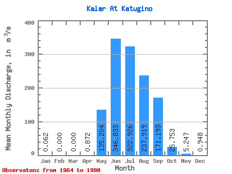
| Statistic | Jan | Feb | Mar | Apr | May | Jun | Jul | Aug | Sep | Oct | Nov | Dec | Annual |
|---|---|---|---|---|---|---|---|---|---|---|---|---|---|
| Mean | 0.06 | 0.00 | 0.00 | 0.87 | 135.20 | 346.83 | 322.93 | 237.92 | 171.19 | 25.75 | 5.25 | 0.95 | 104.57 |
| Standard Deviation | 0.18 | 0.00 | 0.00 | 1.29 | 94.15 | 145.05 | 148.16 | 128.74 | 171.89 | 7.54 | 1.71 | 0.92 | 31.78 |
| Min | 0.00 | 0.00 | 0.00 | 0.00 | 11.00 | 92.50 | 116.00 | 53.30 | 70.10 | 9.63 | 1.24 | 0.00 | 46.78 |
| Max | 0.77 | 0.01 | 0.00 | 5.74 | 452.00 | 613.00 | 715.00 | 528.00 | 962.00 | 46.40 | 9.01 | 3.25 | 173.99 |
| Coefficient of Variation | 2.91 | 5.10 | 1.48 | 0.70 | 0.42 | 0.46 | 0.54 | 1.00 | 0.29 | 0.33 | 0.97 | 0.30 |
 Return to R-Arctic Net Home Page