|
|
|||||||||||||||||
| Point ID: 6185 | Downloads | Plots | Site Data | Other Close Sites | Code: 3122 |
|
|
|||||||||||||||||
| Download | |
|---|---|
| Site Descriptor Information | Site Time Series Data |
| Link to all available data | |
| View: | Time Series | All |
| Units: | m3/s |
| Statistic | Jan | Feb | Mar | Apr | May | Jun | Jul | Aug | Sep | Oct | Nov | Dec | Annual |
|---|---|---|---|---|---|---|---|---|---|---|---|---|---|
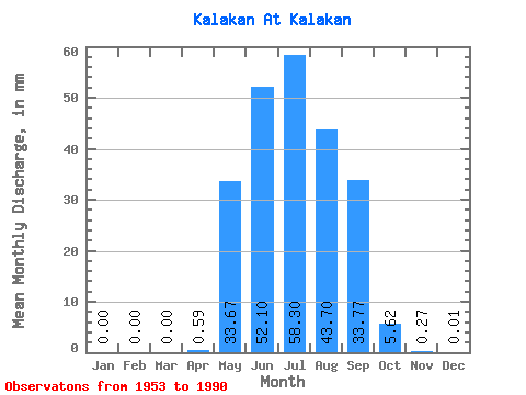
| Mean | 0.00 | 0.00 | 0.00 | 0.59 | 33.67 | 52.09 | 58.29 | 43.69 | 33.77 | 5.62 | 0.27 | 0.01 | 230.06 |
| Standard Deviation | 0.00 | 0.00 | 0.00 | 1.83 | 24.55 | 35.06 | 45.18 | 30.44 | 21.49 | 2.85 | 0.39 | 0.03 | 86.29 |
| Min | 0.00 | 0.00 | 0.00 | 0.00 | 1.17 | 6.59 | 8.38 | 6.23 | 5.69 | 1.33 | 0.01 | 0.00 | 74.91 |
| Max | 0.00 | 0.00 | 0.00 | 9.28 | 97.11 | 134.20 | 207.23 | 114.38 | 86.48 | 13.71 | 1.49 | 0.15 | 482.42 |
| Coefficient of Variation | 3.11 | 0.73 | 0.67 | 0.78 | 0.70 | 0.64 | 0.51 | 1.43 | 3.51 | 0.38 |
| Other Close Sites | ||||||
|---|---|---|---|---|---|---|
| PointID | Latitude | Longitude | Drainage Area | Source | Name | |
| 6172 | "Vitim At Kalakan" | 55.12 | 1720117 | SHI | 960.00 | |
 Return to R-Arctic Net Home Page