|
|
|||||||||||||||||
| Point ID: 6185 | Downloads | Plots | Site Data | Other Close Sites | Code: 3122 |
|
|
|||||||||||||||||
| Download | |
|---|---|
| Site Descriptor Information | Site Time Series Data |
| Link to all available data | |
| View: | Time Series | All |
| Units: | mm |
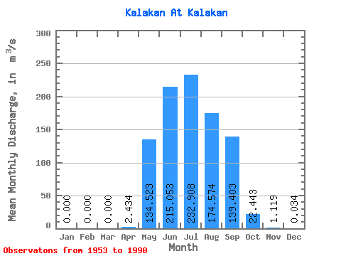
| Statistic | Jan | Feb | Mar | Apr | May | Jun | Jul | Aug | Sep | Oct | Nov | Dec | Annual |
|---|---|---|---|---|---|---|---|---|---|---|---|---|---|
| Mean | 0.00 | 0.00 | 0.00 | 2.43 | 134.52 | 215.05 | 232.91 | 174.57 | 139.40 | 22.44 | 1.12 | 0.03 | 78.00 |
| Standard Deviation | 0.00 | 0.00 | 0.00 | 7.57 | 98.08 | 144.74 | 180.52 | 121.61 | 88.73 | 11.39 | 1.60 | 0.12 | 29.25 |
| Min | 0.00 | 0.00 | 0.00 | 0.00 | 4.66 | 27.20 | 33.50 | 24.90 | 23.50 | 5.30 | 0.06 | 0.00 | 25.40 |
| Max | 0.00 | 0.00 | 0.00 | 38.30 | 388.00 | 554.00 | 828.00 | 457.00 | 357.00 | 54.80 | 6.14 | 0.60 | 163.56 |
| Coefficient of Variation | 3.11 | 0.73 | 0.67 | 0.78 | 0.70 | 0.64 | 0.51 | 1.43 | 3.51 | 0.38 |
| Other Close Sites | ||||||
|---|---|---|---|---|---|---|
| PointID | Latitude | Longitude | Drainage Area | Source | Name | |
| 6172 | "Vitim At Kalakan" | 55.12 | 1720117 | SHI | 960.00 | |
 Return to R-Arctic Net Home Page