|
|
|||||||||||||||||
| Point ID: 6184 | Downloads | Plots | Site Data | Code: 3120 |
|
|
|||||||||||||||||
| Download | |
|---|---|
| Site Descriptor Information | Site Time Series Data |
| Link to all available data | |
| View: | Time Series | All |
| Units: | m3/s |
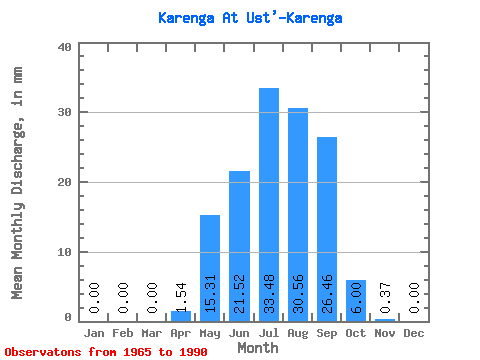
| Statistic | Jan | Feb | Mar | Apr | May | Jun | Jul | Aug | Sep | Oct | Nov | Dec | Annual |
|---|---|---|---|---|---|---|---|---|---|---|---|---|---|
| Mean | 0.00 | 0.00 | 0.00 | 1.54 | 15.30 | 21.52 | 33.47 | 30.56 | 26.46 | 6.00 | 0.37 | 0.00 | 136.32 |
| Standard Deviation | 0.00 | 0.00 | 0.00 | 2.34 | 12.13 | 18.09 | 34.04 | 25.40 | 21.07 | 3.90 | 0.46 | 0.01 | 66.37 |
| Min | 0.00 | 0.00 | 0.00 | 0.00 | 0.65 | 1.66 | 2.13 | 2.89 | 1.22 | 0.60 | 0.00 | 0.00 | 27.54 |
| Max | 0.00 | 0.00 | 0.00 | 7.54 | 44.45 | 67.40 | 135.03 | 97.67 | 71.24 | 14.24 | 2.28 | 0.02 | 310.98 |
| Coefficient of Variation | 1.52 | 0.79 | 0.84 | 1.02 | 0.83 | 0.80 | 0.65 | 1.23 | 2.67 | 0.49 |
 Return to R-Arctic Net Home Page