|
|
|||||||||||||||||
| Point ID: 6184 | Downloads | Plots | Site Data | Code: 3120 |
|
|
|||||||||||||||||
| Download | |
|---|---|
| Site Descriptor Information | Site Time Series Data |
| Link to all available data | |
| View: | Time Series | All |
| Units: | mm |
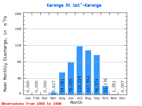
| Statistic | Jan | Feb | Mar | Apr | May | Jun | Jul | Aug | Sep | Oct | Nov | Dec | Annual |
|---|---|---|---|---|---|---|---|---|---|---|---|---|---|
| Mean | 0.00 | 0.00 | 0.00 | 5.62 | 54.06 | 78.56 | 118.24 | 107.95 | 96.57 | 21.18 | 1.35 | 0.01 | 40.86 |
| Standard Deviation | 0.00 | 0.00 | 0.00 | 8.54 | 42.86 | 66.04 | 120.23 | 89.74 | 76.89 | 13.79 | 1.67 | 0.02 | 19.89 |
| Min | 0.00 | 0.00 | 0.00 | 0.00 | 2.28 | 6.04 | 7.52 | 10.20 | 4.44 | 2.13 | 0.00 | 0.00 | 8.25 |
| Max | 0.00 | 0.00 | 0.00 | 27.50 | 157.00 | 246.00 | 477.00 | 345.00 | 260.00 | 50.30 | 8.31 | 0.07 | 93.22 |
| Coefficient of Variation | 1.52 | 0.79 | 0.84 | 1.02 | 0.83 | 0.80 | 0.65 | 1.23 | 2.67 | 0.49 |
 Return to R-Arctic Net Home Page