|
|
|||||||||||||||||
| Point ID: 6180 | Downloads | Plots | Site Data | Code: 3113 |
|
|
|||||||||||||||||
| Download | |
|---|---|
| Site Descriptor Information | Site Time Series Data |
| Link to all available data | |
| View: | Time Series | All |
| Units: | m3/s |
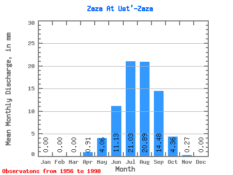
| Statistic | Jan | Feb | Mar | Apr | May | Jun | Jul | Aug | Sep | Oct | Nov | Dec | Annual |
|---|---|---|---|---|---|---|---|---|---|---|---|---|---|
| Mean | 0.00 | 0.00 | 0.00 | 0.91 | 4.06 | 11.13 | 21.03 | 20.89 | 14.48 | 4.36 | 0.27 | 0.00 | 76.43 |
| Standard Deviation | 0.00 | 0.00 | 0.00 | 1.86 | 6.33 | 19.29 | 23.86 | 21.45 | 12.48 | 3.20 | 0.29 | 0.00 | 55.04 |
| Min | 0.00 | 0.00 | 0.00 | 0.00 | 0.14 | 0.04 | 0.73 | 1.08 | 0.25 | 0.41 | 0.00 | 0.00 | 5.79 |
| Max | 0.00 | 0.00 | 0.00 | 9.47 | 35.18 | 104.23 | 83.33 | 84.61 | 44.26 | 12.75 | 1.01 | 0.01 | 189.11 |
| Coefficient of Variation | 2.05 | 1.56 | 1.73 | 1.14 | 1.03 | 0.86 | 0.73 | 1.08 | 5.00 | 0.72 |
 Return to R-Arctic Net Home Page