|
|
|||||||||||||||||
| Point ID: 6180 | Downloads | Plots | Site Data | Code: 3113 |
|
|
|||||||||||||||||
| Download | |
|---|---|
| Site Descriptor Information | Site Time Series Data |
| Link to all available data | |
| View: | Time Series | All |
| Units: | mm |
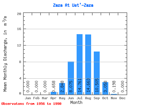
| Statistic | Jan | Feb | Mar | Apr | May | Jun | Jul | Aug | Sep | Oct | Nov | Dec | Annual |
|---|---|---|---|---|---|---|---|---|---|---|---|---|---|
| Mean | 0.00 | 0.00 | 0.00 | 0.66 | 2.85 | 8.07 | 14.76 | 14.66 | 10.51 | 3.06 | 0.20 | 0.00 | 4.55 |
| Standard Deviation | 0.00 | 0.00 | 0.00 | 1.35 | 4.44 | 13.99 | 16.75 | 15.06 | 9.05 | 2.24 | 0.21 | 0.00 | 3.28 |
| Min | 0.00 | 0.00 | 0.00 | 0.00 | 0.10 | 0.03 | 0.51 | 0.76 | 0.18 | 0.29 | 0.00 | 0.00 | 0.34 |
| Max | 0.00 | 0.00 | 0.00 | 6.87 | 24.70 | 75.60 | 58.50 | 59.40 | 32.10 | 8.95 | 0.73 | 0.01 | 11.27 |
| Coefficient of Variation | 2.05 | 1.56 | 1.73 | 1.14 | 1.03 | 0.86 | 0.73 | 1.08 | 5.00 | 0.72 |
 Return to R-Arctic Net Home Page