|
|
|||||||||||||||||
| Point ID: 6177 | Downloads | Plots | Site Data | Code: 3109 |
|
|
|||||||||||||||||
| Download | |
|---|---|
| Site Descriptor Information | Site Time Series Data |
| Link to all available data | |
| View: | Time Series | All |
| Units: | m3/s |
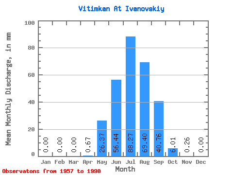
| Statistic | Jan | Feb | Mar | Apr | May | Jun | Jul | Aug | Sep | Oct | Nov | Dec | Annual |
|---|---|---|---|---|---|---|---|---|---|---|---|---|---|
| Mean | 0.00 | 0.00 | 0.00 | 0.67 | 26.37 | 56.44 | 88.25 | 69.38 | 40.76 | 6.00 | 0.26 | 0.00 | 286.17 |
| Standard Deviation | 0.00 | 0.00 | 0.00 | 1.47 | 15.63 | 42.51 | 65.15 | 47.45 | 39.07 | 2.72 | 0.23 | 0.00 | 130.16 |
| Min | 0.00 | 0.00 | 0.00 | 0.00 | 9.51 | 11.93 | 16.80 | 14.43 | 4.65 | 1.30 | 0.00 | 0.00 | 97.63 |
| Max | 0.00 | 0.00 | 0.00 | 7.20 | 73.51 | 228.44 | 287.42 | 173.01 | 228.97 | 11.50 | 0.91 | 0.00 | 567.12 |
| Coefficient of Variation | 2.21 | 0.59 | 0.75 | 0.74 | 0.68 | 0.96 | 0.45 | 0.91 | 0.46 |
 Return to R-Arctic Net Home Page