|
|
|||||||||||||||||
| Point ID: 6177 | Downloads | Plots | Site Data | Code: 3109 |
|
|
|||||||||||||||||
| Download | |
|---|---|
| Site Descriptor Information | Site Time Series Data |
| Link to all available data | |
| View: | Time Series | All |
| Units: | mm |
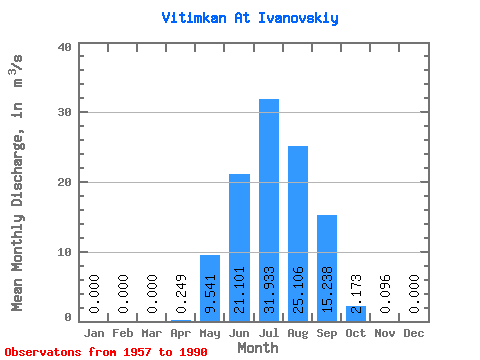
| Statistic | Jan | Feb | Mar | Apr | May | Jun | Jul | Aug | Sep | Oct | Nov | Dec | Annual |
|---|---|---|---|---|---|---|---|---|---|---|---|---|---|
| Mean | 0.00 | 0.00 | 0.00 | 0.25 | 9.54 | 21.10 | 31.93 | 25.11 | 15.24 | 2.17 | 0.10 | 0.00 | 8.79 |
| Standard Deviation | 0.00 | 0.00 | 0.00 | 0.55 | 5.66 | 15.89 | 23.57 | 17.17 | 14.61 | 0.99 | 0.09 | 0.00 | 4.00 |
| Min | 0.00 | 0.00 | 0.00 | 0.00 | 3.44 | 4.46 | 6.08 | 5.22 | 1.74 | 0.47 | 0.00 | 0.00 | 3.00 |
| Max | 0.00 | 0.00 | 0.00 | 2.69 | 26.60 | 85.40 | 104.00 | 62.60 | 85.60 | 4.16 | 0.34 | 0.00 | 17.41 |
| Coefficient of Variation | 2.21 | 0.59 | 0.75 | 0.74 | 0.68 | 0.96 | 0.45 | 0.91 | 0.46 |
 Return to R-Arctic Net Home Page