|
|
|||||||||||||||||
| Point ID: 6160 | Downloads | Plots | Site Data | Code: 3079 |
|
|
|||||||||||||||||
| Download | |
|---|---|
| Site Descriptor Information | Site Time Series Data |
| Link to all available data | |
| View: | Time Series | All |
| Units: | m3/s |
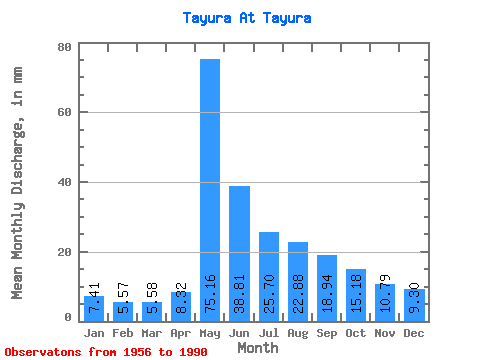
| Statistic | Jan | Feb | Mar | Apr | May | Jun | Jul | Aug | Sep | Oct | Nov | Dec | Annual |
|---|---|---|---|---|---|---|---|---|---|---|---|---|---|
| Mean | 7.41 | 5.62 | 5.58 | 8.32 | 75.15 | 38.81 | 25.70 | 22.88 | 18.94 | 15.18 | 10.79 | 9.30 | 242.36 |
| Standard Deviation | 2.13 | 1.81 | 1.65 | 6.17 | 16.56 | 15.63 | 11.65 | 11.26 | 6.88 | 6.42 | 3.25 | 3.33 | 49.43 |
| Min | 3.96 | 2.58 | 2.68 | 3.18 | 41.72 | 15.50 | 10.81 | 9.27 | 8.16 | 6.88 | 5.62 | 5.53 | 139.13 |
| Max | 12.31 | 9.94 | 9.36 | 38.84 | 105.34 | 78.85 | 63.67 | 60.40 | 36.25 | 41.34 | 18.08 | 22.43 | 351.69 |
| Coefficient of Variation | 0.29 | 0.32 | 0.29 | 0.74 | 0.22 | 0.40 | 0.45 | 0.49 | 0.36 | 0.42 | 0.30 | 0.36 | 0.20 |
 Return to R-Arctic Net Home Page