|
|
|||||||||||||||||
| Point ID: 6160 | Downloads | Plots | Site Data | Code: 3079 |
|
|
|||||||||||||||||
| Download | |
|---|---|
| Site Descriptor Information | Site Time Series Data |
| Link to all available data | |
| View: | Time Series | All |
| Units: | mm |
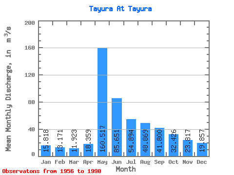
| Statistic | Jan | Feb | Mar | Apr | May | Jun | Jul | Aug | Sep | Oct | Nov | Dec | Annual |
|---|---|---|---|---|---|---|---|---|---|---|---|---|---|
| Mean | 15.82 | 13.17 | 11.92 | 18.36 | 160.52 | 85.65 | 54.89 | 48.87 | 41.80 | 32.43 | 23.82 | 19.86 | 43.92 |
| Standard Deviation | 4.54 | 4.24 | 3.52 | 13.62 | 35.38 | 34.49 | 24.88 | 24.05 | 15.18 | 13.71 | 7.17 | 7.11 | 8.96 |
| Min | 8.45 | 6.05 | 5.73 | 7.01 | 89.10 | 34.20 | 23.10 | 19.80 | 18.00 | 14.70 | 12.40 | 11.80 | 25.22 |
| Max | 26.30 | 23.30 | 20.00 | 85.70 | 225.00 | 174.00 | 136.00 | 129.00 | 80.00 | 88.30 | 39.90 | 47.90 | 63.74 |
| Coefficient of Variation | 0.29 | 0.32 | 0.29 | 0.74 | 0.22 | 0.40 | 0.45 | 0.49 | 0.36 | 0.42 | 0.30 | 0.36 | 0.20 |
 Return to R-Arctic Net Home Page