|
|
|||||||||||||||||
| Point ID: 6157 | Downloads | Plots | Site Data | Code: 3074 |
|
|
|||||||||||||||||
| Download | |
|---|---|
| Site Descriptor Information | Site Time Series Data |
| Link to all available data | |
| View: | Time Series | All |
| Units: | m3/s |
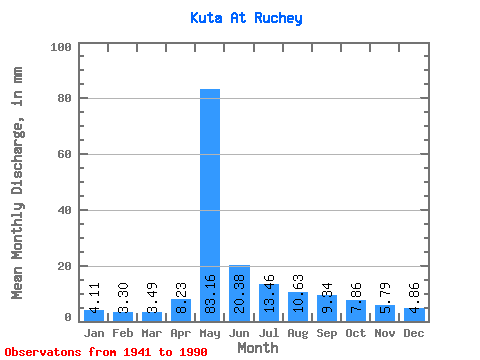
| Statistic | Jan | Feb | Mar | Apr | May | Jun | Jul | Aug | Sep | Oct | Nov | Dec | Annual |
|---|---|---|---|---|---|---|---|---|---|---|---|---|---|
| Mean | 4.11 | 3.33 | 3.49 | 8.23 | 83.14 | 20.38 | 13.46 | 10.63 | 9.34 | 7.86 | 5.79 | 4.86 | 173.12 |
| Standard Deviation | 1.26 | 0.93 | 0.91 | 7.18 | 21.50 | 8.34 | 7.08 | 4.79 | 3.19 | 2.91 | 2.14 | 1.50 | 31.00 |
| Min | 1.96 | 1.76 | 2.08 | 2.50 | 32.28 | 7.15 | 5.98 | 4.64 | 4.54 | 3.35 | 2.57 | 2.63 | 96.30 |
| Max | 6.74 | 5.47 | 5.55 | 32.86 | 128.40 | 44.43 | 33.00 | 26.06 | 18.70 | 17.31 | 11.39 | 8.35 | 240.53 |
| Coefficient of Variation | 0.31 | 0.28 | 0.26 | 0.87 | 0.26 | 0.41 | 0.53 | 0.45 | 0.34 | 0.37 | 0.37 | 0.31 | 0.18 |
 Return to R-Arctic Net Home Page