|
|
|||||||||||||||||
| Point ID: 6157 | Downloads | Plots | Site Data | Code: 3074 |
|
|
|||||||||||||||||
| Download | |
|---|---|
| Site Descriptor Information | Site Time Series Data |
| Link to all available data | |
| View: | Time Series | All |
| Units: | mm |
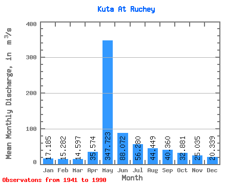
| Statistic | Jan | Feb | Mar | Apr | May | Jun | Jul | Aug | Sep | Oct | Nov | Dec | Annual |
|---|---|---|---|---|---|---|---|---|---|---|---|---|---|
| Mean | 17.18 | 15.28 | 14.60 | 35.57 | 347.72 | 88.07 | 56.28 | 44.45 | 40.36 | 32.88 | 25.04 | 20.34 | 61.44 |
| Standard Deviation | 5.27 | 4.29 | 3.81 | 31.02 | 89.90 | 36.05 | 29.59 | 20.03 | 13.77 | 12.18 | 9.26 | 6.26 | 11.00 |
| Min | 8.19 | 8.08 | 8.68 | 10.80 | 135.00 | 30.90 | 25.00 | 19.40 | 19.60 | 14.00 | 11.10 | 11.00 | 34.17 |
| Max | 28.20 | 25.10 | 23.20 | 142.00 | 537.00 | 192.00 | 138.00 | 109.00 | 80.80 | 72.40 | 49.20 | 34.90 | 85.36 |
| Coefficient of Variation | 0.31 | 0.28 | 0.26 | 0.87 | 0.26 | 0.41 | 0.53 | 0.45 | 0.34 | 0.37 | 0.37 | 0.31 | 0.18 |
 Return to R-Arctic Net Home Page