|
|
|||||||||||||||||
| Point ID: 6156 | Downloads | Plots | Site Data | Code: 3073 |
|
|
|||||||||||||||||
| Download | |
|---|---|
| Site Descriptor Information | Site Time Series Data |
| Link to all available data | |
| View: | Time Series | All |
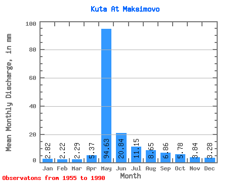
| Units: | m3/s |
| Statistic | Jan | Feb | Mar | Apr | May | Jun | Jul | Aug | Sep | Oct | Nov | Dec | Annual |
|---|---|---|---|---|---|---|---|---|---|---|---|---|---|
| Mean | 2.82 | 2.24 | 2.29 | 5.37 | 94.62 | 20.84 | 11.14 | 8.65 | 6.86 | 5.78 | 3.84 | 3.28 | 166.15 |
| Standard Deviation | 1.14 | 0.94 | 0.96 | 6.53 | 22.15 | 10.90 | 7.00 | 4.75 | 2.65 | 2.46 | 1.84 | 1.43 | 37.74 |
| Min | 1.30 | 0.95 | 0.75 | 1.32 | 46.70 | 6.64 | 3.96 | 3.75 | 3.48 | 2.77 | 1.64 | 1.52 | 85.63 |
| Max | 6.78 | 5.46 | 5.25 | 33.24 | 136.79 | 49.60 | 32.65 | 25.70 | 12.92 | 12.61 | 10.04 | 8.43 | 259.73 |
| Coefficient of Variation | 0.41 | 0.42 | 0.42 | 1.22 | 0.23 | 0.52 | 0.63 | 0.55 | 0.39 | 0.43 | 0.48 | 0.43 | 0.23 |
 Return to R-Arctic Net Home Page