|
|
|||||||||||||||||
| Point ID: 6156 | Downloads | Plots | Site Data | Code: 3073 |
|
|
|||||||||||||||||
| Download | |
|---|---|
| Site Descriptor Information | Site Time Series Data |
| Link to all available data | |
| View: | Time Series | All |
| Units: | mm |
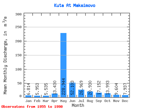
| Statistic | Jan | Feb | Mar | Apr | May | Jun | Jul | Aug | Sep | Oct | Nov | Dec | Annual |
|---|---|---|---|---|---|---|---|---|---|---|---|---|---|
| Mean | 6.81 | 5.95 | 5.54 | 13.43 | 228.94 | 52.10 | 26.97 | 20.93 | 17.15 | 13.99 | 9.60 | 7.94 | 34.11 |
| Standard Deviation | 2.76 | 2.50 | 2.31 | 16.32 | 53.60 | 27.26 | 16.94 | 11.51 | 6.63 | 5.96 | 4.61 | 3.45 | 7.75 |
| Min | 3.14 | 2.53 | 1.81 | 3.30 | 113.00 | 16.60 | 9.57 | 9.07 | 8.71 | 6.69 | 4.10 | 3.68 | 17.58 |
| Max | 16.40 | 14.50 | 12.70 | 83.10 | 331.00 | 124.00 | 79.00 | 62.20 | 32.30 | 30.50 | 25.10 | 20.40 | 53.33 |
| Coefficient of Variation | 0.41 | 0.42 | 0.42 | 1.22 | 0.23 | 0.52 | 0.63 | 0.55 | 0.39 | 0.43 | 0.48 | 0.43 | 0.23 |
 Return to R-Arctic Net Home Page