|
|
|||||||||||||||||
| Point ID: 6138 | Downloads | Plots | Site Data | Code: 3004 |
|
|
|||||||||||||||||
| Download | |
|---|---|
| Site Descriptor Information | Site Time Series Data |
| Link to all available data | |
| View: | Time Series | All |
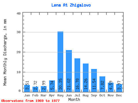
| Units: | m3/s |
| Statistic | Jan | Feb | Mar | Apr | May | Jun | Jul | Aug | Sep | Oct | Nov | Dec | Annual |
|---|---|---|---|---|---|---|---|---|---|---|---|---|---|
| Mean | 3.51 | 2.74 | 2.99 | 5.74 | 30.34 | 21.02 | 16.78 | 14.26 | 11.54 | 7.82 | 4.59 | 3.97 | 124.72 |
| Standard Deviation | 0.74 | 0.39 | 0.39 | 1.08 | 9.12 | 6.12 | 7.39 | 7.19 | 4.15 | 2.10 | 1.51 | 1.22 | 20.97 |
| Min | 2.72 | 2.30 | 2.36 | 4.03 | 16.83 | 15.26 | 7.00 | 6.93 | 6.50 | 4.93 | 2.85 | 2.38 | 95.87 |
| Max | 4.59 | 3.45 | 3.37 | 7.50 | 41.84 | 35.21 | 28.37 | 25.99 | 17.65 | 10.75 | 6.82 | 6.00 | 166.47 |
| Coefficient of Variation | 0.21 | 0.14 | 0.13 | 0.19 | 0.30 | 0.29 | 0.44 | 0.50 | 0.36 | 0.27 | 0.33 | 0.31 | 0.17 |
 Return to R-Arctic Net Home Page