|
|
|||||||||||||||||
| Point ID: 6138 | Downloads | Plots | Site Data | Code: 3004 |
|
|
|||||||||||||||||
| Download | |
|---|---|
| Site Descriptor Information | Site Time Series Data |
| Link to all available data | |
| View: | Time Series | All |
| Units: | mm |
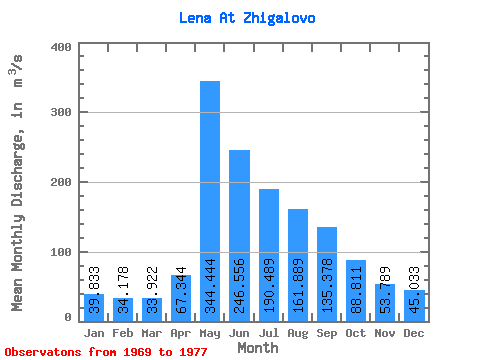
| Statistic | Jan | Feb | Mar | Apr | May | Jun | Jul | Aug | Sep | Oct | Nov | Dec | Annual |
|---|---|---|---|---|---|---|---|---|---|---|---|---|---|
| Mean | 39.83 | 34.18 | 33.92 | 67.34 | 344.44 | 246.56 | 190.49 | 161.89 | 135.38 | 88.81 | 53.79 | 45.03 | 120.14 |
| Standard Deviation | 8.41 | 4.91 | 4.37 | 12.70 | 103.56 | 71.75 | 83.90 | 81.60 | 48.68 | 23.79 | 17.76 | 13.86 | 20.20 |
| Min | 30.90 | 28.70 | 26.80 | 47.30 | 191.00 | 179.00 | 79.40 | 78.70 | 76.20 | 56.00 | 33.40 | 27.00 | 92.35 |
| Max | 52.10 | 43.00 | 38.30 | 88.00 | 475.00 | 413.00 | 322.00 | 295.00 | 207.00 | 122.00 | 80.00 | 68.10 | 160.35 |
| Coefficient of Variation | 0.21 | 0.14 | 0.13 | 0.19 | 0.30 | 0.29 | 0.44 | 0.50 | 0.36 | 0.27 | 0.33 | 0.31 | 0.17 |
 Return to R-Arctic Net Home Page