|
|
|||||||||||||||||
| Point ID: 609 | Downloads | Plots | Site Data | Code: 07AE001 |
|
|
|||||||||||||||||
| Download | |
|---|---|
| Site Descriptor Information | Site Time Series Data |
| Link to all available data | |
| View: | Time Series | All |
| Units: | m3/s |
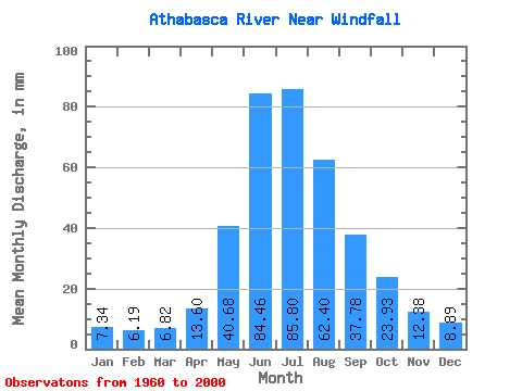
| Statistic | Jan | Feb | Mar | Apr | May | Jun | Jul | Aug | Sep | Oct | Nov | Dec | Annual |
|---|---|---|---|---|---|---|---|---|---|---|---|---|---|
| Mean | 7.34 | 6.25 | 6.82 | 13.60 | 40.68 | 84.46 | 85.78 | 62.39 | 37.78 | 23.92 | 12.38 | 8.89 | 405.81 |
| Standard Deviation | 2.02 | 0.94 | 1.39 | 4.32 | 10.89 | 18.95 | 20.77 | 14.35 | 9.52 | 6.70 | 3.39 | 2.81 | 65.63 |
| Min | 4.97 | 4.44 | 3.84 | 6.02 | 25.14 | 55.41 | 51.65 | 42.22 | 20.50 | 13.09 | 7.43 | 5.59 | 297.55 |
| Max | 13.94 | 8.13 | 12.06 | 22.61 | 72.96 | 136.21 | 148.93 | 94.28 | 64.01 | 41.13 | 19.97 | 18.58 | 572.55 |
| Coefficient of Variation | 0.28 | 0.15 | 0.20 | 0.32 | 0.27 | 0.22 | 0.24 | 0.23 | 0.25 | 0.28 | 0.27 | 0.32 | 0.16 |
 Return to R-Arctic Net Home Page