|
|
|||||||||||||||||
| Point ID: 609 | Downloads | Plots | Site Data | Code: 07AE001 |
|
|
|||||||||||||||||
| Download | |
|---|---|
| Site Descriptor Information | Site Time Series Data |
| Link to all available data | |
| View: | Time Series | All |
| Units: | mm |
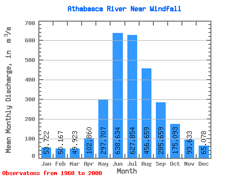
| Statistic | Jan | Feb | Mar | Apr | May | Jun | Jul | Aug | Sep | Oct | Nov | Dec | Annual |
|---|---|---|---|---|---|---|---|---|---|---|---|---|---|
| Mean | 53.72 | 50.17 | 49.92 | 102.86 | 297.71 | 638.63 | 627.85 | 456.66 | 285.66 | 175.09 | 93.63 | 65.08 | 252.02 |
| Standard Deviation | 14.77 | 7.54 | 10.15 | 32.70 | 79.68 | 143.31 | 152.05 | 105.02 | 71.96 | 49.03 | 25.66 | 20.56 | 40.76 |
| Min | 36.40 | 35.70 | 28.10 | 45.50 | 184.00 | 419.00 | 378.00 | 309.00 | 155.00 | 95.80 | 56.20 | 40.90 | 184.79 |
| Max | 102.00 | 65.30 | 88.30 | 171.00 | 534.00 | 1030.00 | 1090.00 | 690.00 | 484.00 | 301.00 | 151.00 | 136.00 | 355.57 |
| Coefficient of Variation | 0.28 | 0.15 | 0.20 | 0.32 | 0.27 | 0.22 | 0.24 | 0.23 | 0.25 | 0.28 | 0.27 | 0.32 | 0.16 |
 Return to R-Arctic Net Home Page