|
|
|||||||||||||||||
| Point ID: 6040 | Downloads | Plots | Site Data | Code: 7008 |
|
|
|||||||||||||||||
| Download | |
|---|---|
| Site Descriptor Information | Site Time Series Data |
| Link to all available data | |
| View: | Time Series | All |
| Units: | m3/s |
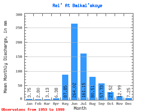
| Statistic | Jan | Feb | Mar | Apr | May | Jun | Jul | Aug | Sep | Oct | Nov | Dec | Annual |
|---|---|---|---|---|---|---|---|---|---|---|---|---|---|
| Mean | 3.75 | 2.82 | 3.13 | 6.38 | 87.83 | 264.02 | 161.13 | 80.49 | 57.73 | 27.52 | 12.99 | 7.25 | 726.03 |
| Standard Deviation | 2.96 | 2.81 | 3.23 | 9.63 | 70.98 | 63.62 | 55.09 | 30.41 | 25.33 | 9.76 | 7.29 | 4.36 | 150.98 |
| Min | 0.17 | 0.00 | 0.00 | 0.00 | 11.05 | 153.60 | 69.90 | 32.26 | 20.57 | 8.41 | 2.06 | 1.89 | 366.58 |
| Max | 11.71 | 8.87 | 12.99 | 58.06 | 301.33 | 470.86 | 304.17 | 135.55 | 125.26 | 54.32 | 45.35 | 21.44 | 977.27 |
| Coefficient of Variation | 0.79 | 0.99 | 1.03 | 1.51 | 0.81 | 0.24 | 0.34 | 0.38 | 0.44 | 0.35 | 0.56 | 0.60 | 0.21 |
 Return to R-Arctic Net Home Page