|
|
|||||||||||||||||
| Point ID: 6040 | Downloads | Plots | Site Data | Code: 7008 |
|
|
|||||||||||||||||
| Download | |
|---|---|
| Site Descriptor Information | Site Time Series Data |
| Link to all available data | |
| View: | Time Series | All |
| Units: | mm |
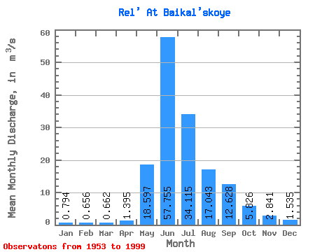
| Statistic | Jan | Feb | Mar | Apr | May | Jun | Jul | Aug | Sep | Oct | Nov | Dec | Annual |
|---|---|---|---|---|---|---|---|---|---|---|---|---|---|
| Mean | 0.79 | 0.66 | 0.66 | 1.40 | 18.60 | 57.76 | 34.12 | 17.04 | 12.63 | 5.83 | 2.84 | 1.54 | 13.04 |
| Standard Deviation | 0.63 | 0.65 | 0.68 | 2.11 | 15.03 | 13.92 | 11.66 | 6.44 | 5.54 | 2.06 | 1.59 | 0.92 | 2.71 |
| Min | 0.04 | 0.00 | 0.00 | 0.00 | 2.34 | 33.60 | 14.80 | 6.83 | 4.50 | 1.78 | 0.45 | 0.40 | 6.59 |
| Max | 2.48 | 2.06 | 2.75 | 12.70 | 63.80 | 103.00 | 64.40 | 28.70 | 27.40 | 11.50 | 9.92 | 4.54 | 17.56 |
| Coefficient of Variation | 0.79 | 0.99 | 1.03 | 1.51 | 0.81 | 0.24 | 0.34 | 0.38 | 0.44 | 0.35 | 0.56 | 0.60 | 0.21 |
 Return to R-Arctic Net Home Page