|
|
|||||||||||||||||
| Point ID: 599 | Downloads | Plots | Site Data | Code: 07AD001 |
|
|
|||||||||||||||||
| Download | |
|---|---|
| Site Descriptor Information | Site Time Series Data |
| Link to all available data | |
| View: | Time Series | All |
| Units: | m3/s |
| Statistic | Jan | Feb | Mar | Apr | May | Jun | Jul | Aug | Sep | Oct | Nov | Dec | Annual |
|---|---|---|---|---|---|---|---|---|---|---|---|---|---|
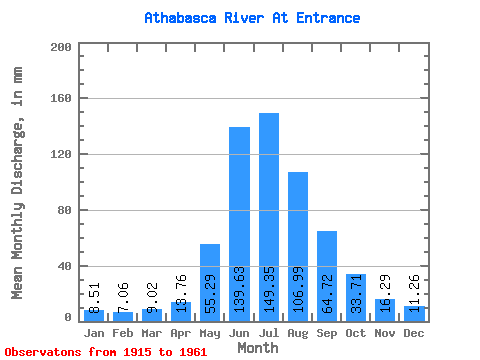
| Mean | 8.51 | 7.12 | 9.02 | 13.76 | 55.28 | 139.63 | 149.33 | 106.98 | 64.72 | 33.71 | 16.29 | 11.26 | 616.89 |
| Standard Deviation | 1.86 | 2.04 | 2.12 | 6.72 | 21.79 | 22.62 | 31.11 | 18.12 | 12.47 | 7.30 | 3.55 | 2.96 | 52.80 |
| Min | 5.14 | 2.97 | 4.13 | 6.15 | 24.39 | 94.38 | 99.76 | 71.94 | 42.43 | 21.19 | 10.23 | 6.88 | 526.83 |
| Max | 13.66 | 11.88 | 13.60 | 38.35 | 104.53 | 185.22 | 248.13 | 148.65 | 91.66 | 55.92 | 27.20 | 17.37 | 719.81 |
| Coefficient of Variation | 0.22 | 0.29 | 0.23 | 0.49 | 0.39 | 0.16 | 0.21 | 0.17 | 0.19 | 0.22 | 0.22 | 0.26 | 0.09 |
 Return to R-Arctic Net Home Page