|
|
|||||||||||||||||
| Point ID: 599 | Downloads | Plots | Site Data | Code: 07AD001 |
|
|
|||||||||||||||||
| Download | |
|---|---|
| Site Descriptor Information | Site Time Series Data |
| Link to all available data | |
| View: | Time Series | All |
| Units: | mm |
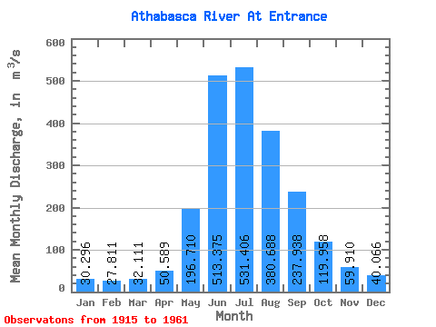
| Statistic | Jan | Feb | Mar | Apr | May | Jun | Jul | Aug | Sep | Oct | Nov | Dec | Annual |
|---|---|---|---|---|---|---|---|---|---|---|---|---|---|
| Mean | 30.30 | 27.81 | 32.11 | 50.59 | 196.71 | 513.38 | 531.41 | 380.69 | 237.94 | 119.96 | 59.91 | 40.07 | 186.28 |
| Standard Deviation | 6.63 | 7.98 | 7.54 | 24.72 | 77.54 | 83.17 | 110.70 | 64.48 | 45.86 | 25.99 | 13.06 | 10.53 | 15.95 |
| Min | 18.30 | 11.60 | 14.70 | 22.60 | 86.80 | 347.00 | 355.00 | 256.00 | 156.00 | 75.40 | 37.60 | 24.50 | 159.08 |
| Max | 48.60 | 46.40 | 48.40 | 141.00 | 372.00 | 681.00 | 883.00 | 529.00 | 337.00 | 199.00 | 100.00 | 61.80 | 217.36 |
| Coefficient of Variation | 0.22 | 0.29 | 0.23 | 0.49 | 0.39 | 0.16 | 0.21 | 0.17 | 0.19 | 0.22 | 0.22 | 0.26 | 0.09 |
 Return to R-Arctic Net Home Page