|
|
|||||||||||||||||
| Point ID: 5943 | Downloads | Plots | Site Data | Code: 1596 |
|
|
|||||||||||||||||
| Download | |
|---|---|
| Site Descriptor Information | Site Time Series Data |
| Link to all available data | |
| View: | Time Series | All |
| Units: | m3/s |
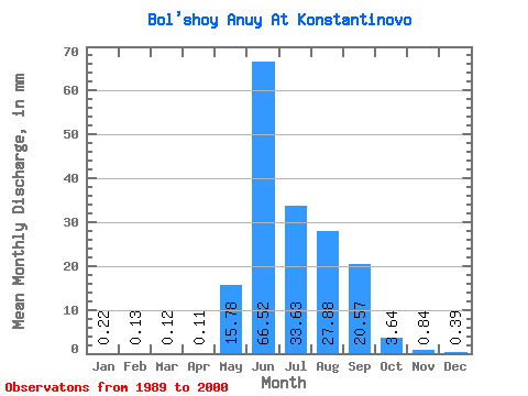
| Statistic | Jan | Feb | Mar | Apr | May | Jun | Jul | Aug | Sep | Oct | Nov | Dec | Annual |
|---|---|---|---|---|---|---|---|---|---|---|---|---|---|
| Mean | 0.21 | 0.13 | 0.12 | 0.12 | 15.78 | 66.52 | 33.63 | 27.87 | 20.57 | 3.64 | 0.84 | 0.39 | 169.67 |
| Standard Deviation | 0.06 | 0.03 | 0.04 | 0.03 | 9.82 | 23.50 | 20.60 | 15.98 | 12.32 | 1.59 | 0.24 | 0.12 | 45.41 |
| Min | 0.07 | 0.05 | 0.06 | 0.03 | 0.13 | 26.08 | 6.05 | 7.88 | 8.26 | 1.88 | 0.50 | 0.21 | 100.30 |
| Max | 0.31 | 0.19 | 0.21 | 0.18 | 30.72 | 107.13 | 92.33 | 70.73 | 61.14 | 8.37 | 1.34 | 0.64 | 282.60 |
| Coefficient of Variation | 0.27 | 0.25 | 0.32 | 0.30 | 0.62 | 0.35 | 0.61 | 0.57 | 0.60 | 0.44 | 0.29 | 0.31 | 0.27 |
 Return to R-Arctic Net Home Page