|
|
|||||||||||||||||
| Point ID: 5943 | Downloads | Plots | Site Data | Code: 1596 |
|
|
|||||||||||||||||
| Download | |
|---|---|
| Site Descriptor Information | Site Time Series Data |
| Link to all available data | |
| View: | Time Series | All |
| Units: | mm |
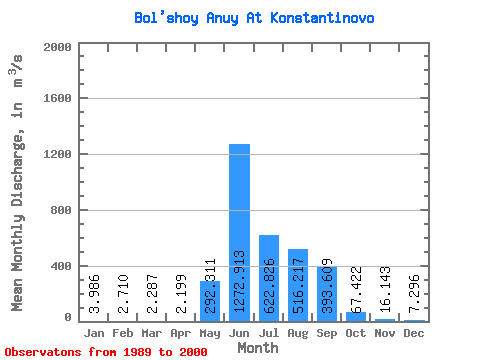
| Statistic | Jan | Feb | Mar | Apr | May | Jun | Jul | Aug | Sep | Oct | Nov | Dec | Annual |
|---|---|---|---|---|---|---|---|---|---|---|---|---|---|
| Mean | 3.99 | 2.71 | 2.29 | 2.20 | 292.31 | 1272.91 | 622.83 | 516.22 | 393.61 | 67.42 | 16.14 | 7.30 | 266.66 |
| Standard Deviation | 1.08 | 0.69 | 0.73 | 0.66 | 181.98 | 449.78 | 381.52 | 296.04 | 235.67 | 29.47 | 4.67 | 2.26 | 71.36 |
| Min | 1.33 | 1.10 | 1.05 | 0.65 | 2.46 | 499.00 | 112.00 | 146.00 | 158.00 | 34.90 | 9.49 | 3.92 | 157.62 |
| Max | 5.71 | 3.83 | 3.90 | 3.37 | 569.00 | 2050.00 | 1710.00 | 1310.00 | 1170.00 | 155.00 | 25.60 | 11.90 | 444.14 |
| Coefficient of Variation | 0.27 | 0.25 | 0.32 | 0.30 | 0.62 | 0.35 | 0.61 | 0.57 | 0.60 | 0.44 | 0.29 | 0.31 | 0.27 |
 Return to R-Arctic Net Home Page