|
|
|||||||||||||||||
| Point ID: 5921 | Downloads | Plots | Site Data | Code: 1504 |
|
|
|||||||||||||||||
| Download | |
|---|---|
| Site Descriptor Information | Site Time Series Data |
| Link to all available data | |
| View: | Time Series | All |
| Units: | m3/s |
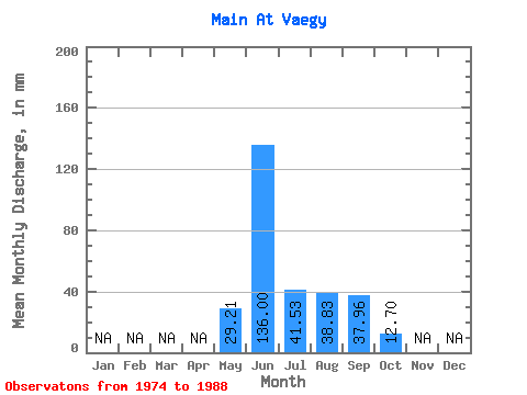
| Statistic | Jan | Feb | Mar | Apr | May | Jun | Jul | Aug | Sep | Oct | Nov | Dec | Annual |
|---|---|---|---|---|---|---|---|---|---|---|---|---|---|
| Mean | 29.20 | 136.00 | 41.53 | 38.82 | 37.96 | 12.70 | |||||||
| Standard Deviation | 15.90 | 30.45 | 23.04 | 15.93 | 18.86 | 5.88 | |||||||
| Min | 5.80 | 87.38 | 14.54 | 12.81 | 14.91 | 3.33 | |||||||
| Max | 54.14 | 199.28 | 109.14 | 73.57 | 70.51 | 24.33 | |||||||
| Coefficient of Variation | 0.54 | 0.22 | 0.56 | 0.41 | 0.50 | 0.46 |
 Return to R-Arctic Net Home Page