|
|
|||||||||||||||||
| Point ID: 5921 | Downloads | Plots | Site Data | Code: 1504 |
|
|
|||||||||||||||||
| Download | |
|---|---|
| Site Descriptor Information | Site Time Series Data |
| Link to all available data | |
| View: | Time Series | All |
| Units: | mm |
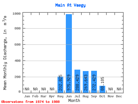
| Statistic | Jan | Feb | Mar | Apr | May | Jun | Jul | Aug | Sep | Oct | Nov | Dec | Annual |
|---|---|---|---|---|---|---|---|---|---|---|---|---|---|
| Mean | 202.82 | 975.93 | 288.43 | 269.64 | 272.43 | 88.19 | |||||||
| Standard Deviation | 110.44 | 218.49 | 160.01 | 110.66 | 135.30 | 40.84 | |||||||
| Min | 40.30 | 627.00 | 101.00 | 89.00 | 107.00 | 23.10 | |||||||
| Max | 376.00 | 1430.00 | 758.00 | 511.00 | 506.00 | 169.00 | |||||||
| Coefficient of Variation | 0.54 | 0.22 | 0.56 | 0.41 | 0.50 | 0.46 |
 Return to R-Arctic Net Home Page