|
|
|||||||||||||||||
| Point ID: 5909 | Downloads | Plots | Site Data | Code: 1397 |
|
|
|||||||||||||||||
| Download | |
|---|---|
| Site Descriptor Information | Site Time Series Data |
| Link to all available data | |
| View: | Time Series | All |
| Units: | m3/s |
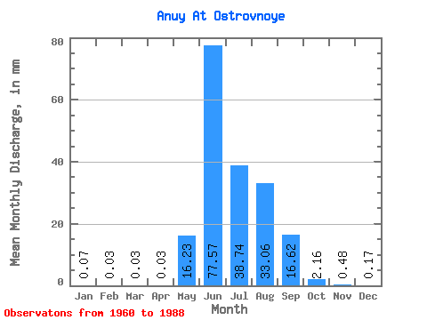
| Statistic | Jan | Feb | Mar | Apr | May | Jun | Jul | Aug | Sep | Oct | Nov | Dec | Annual |
|---|---|---|---|---|---|---|---|---|---|---|---|---|---|
| Mean | 0.07 | 0.03 | 0.03 | 0.03 | 16.22 | 77.57 | 38.73 | 33.05 | 16.62 | 2.16 | 0.48 | 0.17 | 190.58 |
| Standard Deviation | 0.04 | 0.02 | 0.02 | 0.01 | 19.34 | 33.17 | 17.59 | 14.85 | 9.34 | 1.06 | 0.17 | 0.09 | 43.97 |
| Min | 0.00 | 0.00 | 0.00 | 0.00 | 0.17 | 31.28 | 13.39 | 8.80 | 5.15 | 0.93 | 0.14 | 0.02 | 125.15 |
| Max | 0.14 | 0.07 | 0.06 | 0.05 | 95.52 | 170.21 | 91.94 | 67.75 | 44.41 | 5.49 | 0.72 | 0.35 | 265.25 |
| Coefficient of Variation | 0.54 | 0.82 | 0.54 | 0.54 | 1.19 | 0.43 | 0.45 | 0.45 | 0.56 | 0.49 | 0.36 | 0.55 | 0.23 |
 Return to R-Arctic Net Home Page