|
|
|||||||||||||||||
| Point ID: 5909 | Downloads | Plots | Site Data | Code: 1397 |
|
|
|||||||||||||||||
| Download | |
|---|---|
| Site Descriptor Information | Site Time Series Data |
| Link to all available data | |
| View: | Time Series | All |
| Units: | mm |
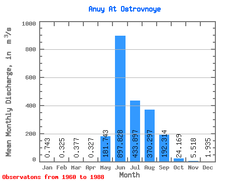
| Statistic | Jan | Feb | Mar | Apr | May | Jun | Jul | Aug | Sep | Oct | Nov | Dec | Annual |
|---|---|---|---|---|---|---|---|---|---|---|---|---|---|
| Mean | 0.74 | 0.33 | 0.38 | 0.33 | 181.74 | 897.83 | 433.90 | 370.30 | 192.31 | 24.17 | 5.52 | 1.94 | 181.16 |
| Standard Deviation | 0.40 | 0.27 | 0.20 | 0.17 | 216.62 | 383.87 | 197.06 | 166.40 | 108.14 | 11.93 | 1.97 | 1.05 | 41.80 |
| Min | 0.02 | 0.00 | 0.03 | 0.04 | 1.86 | 362.00 | 150.00 | 98.60 | 59.60 | 10.40 | 1.67 | 0.24 | 118.97 |
| Max | 1.51 | 0.90 | 0.70 | 0.59 | 1070.00 | 1970.00 | 1030.00 | 759.00 | 514.00 | 61.50 | 8.34 | 3.90 | 252.14 |
| Coefficient of Variation | 0.54 | 0.82 | 0.54 | 0.54 | 1.19 | 0.43 | 0.45 | 0.45 | 0.56 | 0.49 | 0.36 | 0.55 | 0.23 |
 Return to R-Arctic Net Home Page