|
|
|||||||||||||||||
| Point ID: 5902 | Downloads | Plots | Site Data | Code: 1367 |
|
|
|||||||||||||||||
| Download | |
|---|---|
| Site Descriptor Information | Site Time Series Data |
| Link to all available data | |
| View: | Time Series | All |
| Units: | m3/s |
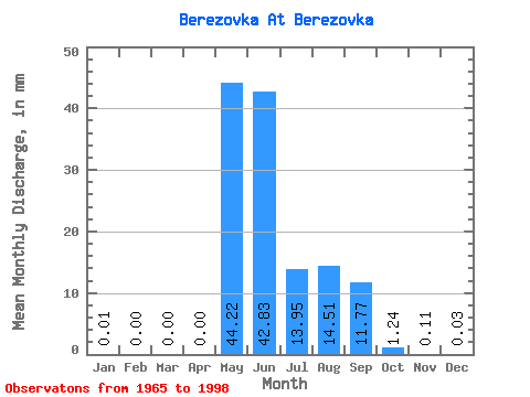
| Statistic | Jan | Feb | Mar | Apr | May | Jun | Jul | Aug | Sep | Oct | Nov | Dec | Annual |
|---|---|---|---|---|---|---|---|---|---|---|---|---|---|
| Mean | 0.01 | 0.01 | 0.01 | 0.00 | 44.22 | 42.83 | 13.95 | 14.51 | 11.77 | 1.24 | 0.11 | 0.03 | 128.81 |
| Standard Deviation | 0.02 | 0.01 | 0.01 | 0.01 | 21.18 | 34.24 | 14.44 | 15.79 | 10.91 | 1.12 | 0.11 | 0.03 | 48.65 |
| Min | 0.00 | 0.00 | 0.00 | 0.00 | 0.04 | 6.63 | 0.53 | 0.63 | 0.90 | 0.19 | 0.00 | 0.00 | 42.26 |
| Max | 0.09 | 0.06 | 0.05 | 0.04 | 101.03 | 156.53 | 63.30 | 56.34 | 45.11 | 5.77 | 0.60 | 0.12 | 239.81 |
| Coefficient of Variation | 1.94 | 2.42 | 2.24 | 2.21 | 0.48 | 0.80 | 1.03 | 1.09 | 0.93 | 0.91 | 1.01 | 1.05 | 0.38 |
 Return to R-Arctic Net Home Page