|
|
|||||||||||||||||
| Point ID: 5902 | Downloads | Plots | Site Data | Code: 1367 |
|
|
|||||||||||||||||
| Download | |
|---|---|
| Site Descriptor Information | Site Time Series Data |
| Link to all available data | |
| View: | Time Series | All |
| Units: | mm |
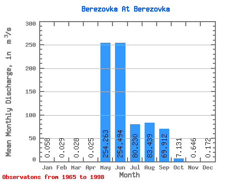
| Statistic | Jan | Feb | Mar | Apr | May | Jun | Jul | Aug | Sep | Oct | Nov | Dec | Annual |
|---|---|---|---|---|---|---|---|---|---|---|---|---|---|
| Mean | 0.06 | 0.03 | 0.03 | 0.03 | 254.26 | 254.49 | 80.23 | 83.44 | 69.91 | 7.13 | 0.65 | 0.17 | 62.86 |
| Standard Deviation | 0.11 | 0.07 | 0.06 | 0.06 | 121.83 | 203.41 | 83.01 | 90.77 | 64.80 | 6.47 | 0.65 | 0.18 | 23.74 |
| Min | 0.00 | 0.00 | 0.00 | 0.00 | 0.23 | 39.40 | 3.03 | 3.60 | 5.33 | 1.11 | 0.00 | 0.00 | 20.62 |
| Max | 0.53 | 0.35 | 0.27 | 0.23 | 581.00 | 930.00 | 364.00 | 324.00 | 268.00 | 33.20 | 3.56 | 0.71 | 117.02 |
| Coefficient of Variation | 1.94 | 2.42 | 2.24 | 2.21 | 0.48 | 0.80 | 1.03 | 1.09 | 0.93 | 0.91 | 1.01 | 1.05 | 0.38 |
 Return to R-Arctic Net Home Page