|
|
|||||||||||||||||
| Point ID: 5897 | Downloads | Plots | Site Data | Code: 1341 |
|
|
|||||||||||||||||
| Download | |
|---|---|
| Site Descriptor Information | Site Time Series Data |
| Link to all available data | |
| View: | Time Series | All |
| Units: | m3/s |
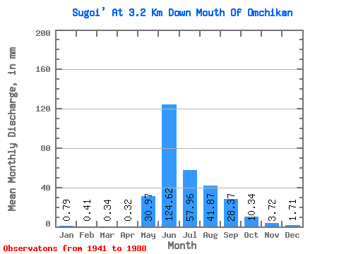
| Statistic | Jan | Feb | Mar | Apr | May | Jun | Jul | Aug | Sep | Oct | Nov | Dec | Annual |
|---|---|---|---|---|---|---|---|---|---|---|---|---|---|
| Mean | 0.79 | 0.41 | 0.34 | 0.32 | 30.96 | 124.62 | 57.95 | 41.86 | 28.37 | 10.34 | 3.72 | 1.71 | 303.75 |
| Standard Deviation | 0.41 | 0.21 | 0.19 | 0.19 | 22.94 | 48.53 | 24.88 | 19.04 | 15.16 | 4.17 | 1.32 | 0.81 | 73.37 |
| Min | 0.20 | 0.06 | 0.04 | 0.04 | 0.67 | 52.90 | 21.22 | 14.21 | 10.36 | 5.24 | 1.64 | 0.44 | 194.12 |
| Max | 2.06 | 1.18 | 1.27 | 1.00 | 117.96 | 282.12 | 144.38 | 109.76 | 74.94 | 24.32 | 7.01 | 4.07 | 490.86 |
| Coefficient of Variation | 0.52 | 0.50 | 0.57 | 0.58 | 0.74 | 0.39 | 0.43 | 0.46 | 0.53 | 0.40 | 0.36 | 0.47 | 0.24 |
 Return to R-Arctic Net Home Page